About Kokino
This part of our web site is dedicated to archaeo-astronomical site Kokino, located in the northeast region of Macedonia and gives an overview about the location and its scientific meaning

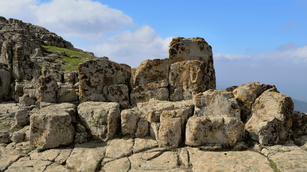
Approximately 35 km northeast of Kumanovo, on the left side of the asphalt road that leads from the village of Dragomance to the village of Arbanaško, rises the impressive neo-volcanic hill which, with its height of 1,013 m dominates over its surroundings and the village of Kokino that lies at its foot. At the very hilltop, known among the local population as Tatićev Kamen, two platforms stretching in the direction west/east and with the difference in altitude of ca. 20 m are made in the andesite rocks, covering an area ca. 90 m long and ca. 50 m wide. The most striking feature on the lower, west platform, is a block of several stone seats hewn into the rock and positioned in such a manner that the person sitting in them faces the east horizon. The upper platform is a flattened area also hewn into the rock, covered with a relatively thin layer of humus which, during the first excavations in 2001, yielded very rich and varied archaeological material.
The archaeological excavations that continued in the years that followed dated the site to the Bronze Age in the development of the human civilization (approximately the entire 2nd millennium BC), while most of the finds come from the Late Bronze Age (14th to 11th centuries BC). Among the wide repertory of shapes and forms of the ceramic vessels that have been unearthed, those that are utilitarian in character, that is, vessels in which food was stored and cooked, prevail. An exclusive find from this site is the mould used for the casting of a bronze amulet, a rare form of a bronze pendant.
The earliest finds date from the Early Bronze Age (19th to 17th centuries BC) and the latest, from the period known as the advanced Iron Age, ca. 7th century BC. The majority of topographic features of this site point to its perception as a holy mountain on which mountain rituals were performed, linked to the belief of the prehistoric inhabitants that the rocky mountain peak is the abode of deities and the place where they could communicate with them.

One of the mountain rituals for which archaeological traces have been recorded on the highest point of this site was probably linked to the fertility cult. The second ritual was performed in midsummer (today, the last day of the month of July), when the rising Sun could be seen in the specially made marker immediately below the highest peak elevation of the site. Since in the past the marker was probably covered, a powerful effect must have been produced by a strong sunbeam that passed above the upper, east platform. The sunbeam casts light only on one of the thrones on the lower platform since a special cut was made in the vertical rock that separates the two platforms, which lets through the sunbeam in this direction. Thus, in this ritual, the divine Sun passed its legitimacy and authority onto the one who sat on the throne illuminated by the sunbeam in this manner.
HAEMUS organized a lecture about “The Sky above Kokino” by Olgica Kuzmanovska, Ph.D
Astronomical explorations revealed stone markers cut off from the rocks which confirm the use of this site as an observatory in the course of the entire 2nd millennium BC. The best-preserved Sun marker is the marker in which the Sun appears on the day of the summer solstice (21 June). The markers for the spring and autumnal equinox (21 March and 23 September) and the marker for the winter solstice (22 December) partially survive. The meticulously made markers for the designation of the places indicating the rising of the Full Moon on the horizon in uncharacteristic positions prove that on this site, astronomical observations were made on a daily basis over a period of several decades. On the basis of these observations, a lunar calendar was made with a cycle of 19 years, with a precision that remains astounding even today.


